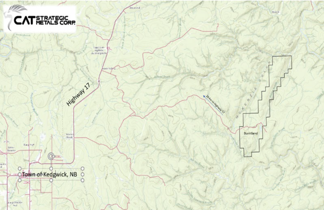
Forty minutes from Saint-Quentin, New Brunswick, and an hour from Bathurst, the property is accessible year round by road, twenty-six kilometers off of Highway 17 near Kedgwick, NB.
Historical Work From 1968 to 1978, the Keevil Mining Group worked on the entire claims area, and has been covered by ground and airborne geophysical surveys, including magnetometer, VLF, S.P., Resistivity, Induced Polarization, as well as by geochemical surveys (soil, quaternary sediments, stream sediments), and mapping surveys. All of these surveys were followed by trenching and drilling programs.
This work resulted in the discovery of three copper occurrences associated with skarnified rocks: Burntland Lake at 4 km to the Southwest; the Endrocky; and the Rockmack to the North. On the Burntland Lake group of claims, four copper occurrences were found by trenching and drilling. Eighteen holes were drilled for a total length of 2,058.31 m (BL-01-18). Those holes investigated RADEM and I.P. anomalies or were designed to test the possible down-dip and lateral extensions of mineralization found in the trenches. All holes were shallow ~100m except one. In 1989, Noranda Exploration staked 58 claims covering the Burntland lake area, south of the Legacy Copper-Silver deposit. The Burntland Lake area was staked due to the proximity of gold anomalies and indicator element anomalies to significant base metal occurrences, and also because gold had been intersected in drilling along strike (6.13 g/t Au over 0.52 m) at the Legacy Copper-Silver deposit. Soil anomalies with coincident IP anomalies (a 0.6 m wide zone containing 4.82% Cu was encountered in the second trench). The 1991 drill holes were targeted on bedrock Cu occurrences from the trenching program and Cu anomalies with chargeability coincidence. Twenty-two (22) holes were drilled in the legacy area for a total length of 3,454 m. Low grade chalcopyrite and magnetite bearing garnet-diopside skarn units were encountered. The best interval was 5.44 m grading 1.56% Cu. Garnet-diopside skarn thicknesses exceed 40 m in two intersections
Noranda Exploration carried out soil sampling and prospecting in 1991 in the Burntland Lake area targeting late‐stage gold mineralization associated with the skarn‐porphyry system. The resampling of old trenches gave precious‐metal assays up to 1 g/t Au and 87 g/t Ag (assessment file 473981). Three samples ran between 6% and 8% Cu. Noranda Exploration company carried out work on the Burntland Lake Project area (474432, 1994). A Transient EM survey was done over part of the grid; the area covered the Burntland Lake deposit and drill‐intersected mineralization to the North (10.2 m of 0.43% Cu). A deep‐penetrating EM was recommended over areas of known metasomatism and mineralization. A pole‐dipole IP / Resistivity survey was conducted by Vickers Geophysics Inc of Bathurst during the period August 14 – 20, 2012. This work and
Vickers in the companion report. The survey covers 4.0 km along four one kilometer cut lines that were surveyed to test for continuation of the zone to the North and at depth. The survey indicates continued chargeability north of an area where hole MC-96-1 had intersected 0.39% Cu + 52g/t Ag / 11.0 meters in 1996 and an earlier hole, MC-92-13 located about 150 m to the northwest had intersected 10.2m grading 0.43% Cu. The survey also indicated that the area west of the four surveyed lines warrants further work. In 2013, Coriolis Copper Inc. conducted a magnetometry survey covering half of the property. In 2020 a 90-meter trench was excavated by prospector T. Lavolie. It uncovered a good copper average of 1.57% Cu.
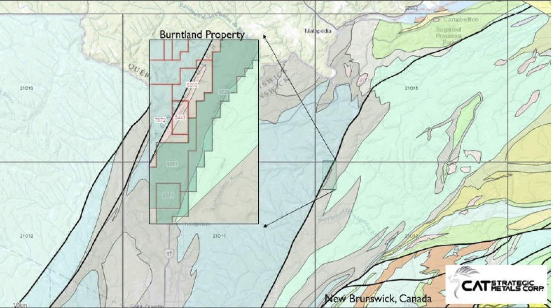
Geological Interpretation A carbonate facies called the whitehead formation is situated between two known fault systems, the Mackenzie Gulch fault, and the rocky brock fault. The area is comprised of four different rock formations. First, the Argillaceous-Limestone which is a grey silicified meta-sedimentary layered with sections of veinlets or veins of calcite-quartz, dipping at 180/80 (RHR) The second facies are quartz-feldspar porphyry rock, which tends to dip steeply in line with bedding; its color changes from green to light blue depending on the rock’s makeup. The quartz-feldspar porphyry is not related to the Mackenzie Gulch porphyry found on the western part of the property and may be instead linked to a pluton underneath the area (2020, Lentz). This pluton would supply the necessary fluids associated with the mineralization event.
– 3 –
The third facies are the skarn. Depending on the amount of alteration the rock (Argillaceous-Limestone/siltstone) has undergone, and how much mineralization is seen in the rock, this can be associated with breccias and other altered forms, and contain values from 0.5% to 16% cooper in hand specimens making up much of the trench in question. The fourth facies to the south, is a Plagioclase-Hornfels-Porphyry suite with magnetite inclusions. This suite may constitute the magnetic anomaly in the south, seen in the geophysical report found in figure 3 below. It is a folded construct that is definitive of the mineralization encountered in the area and is a good target for drilling.
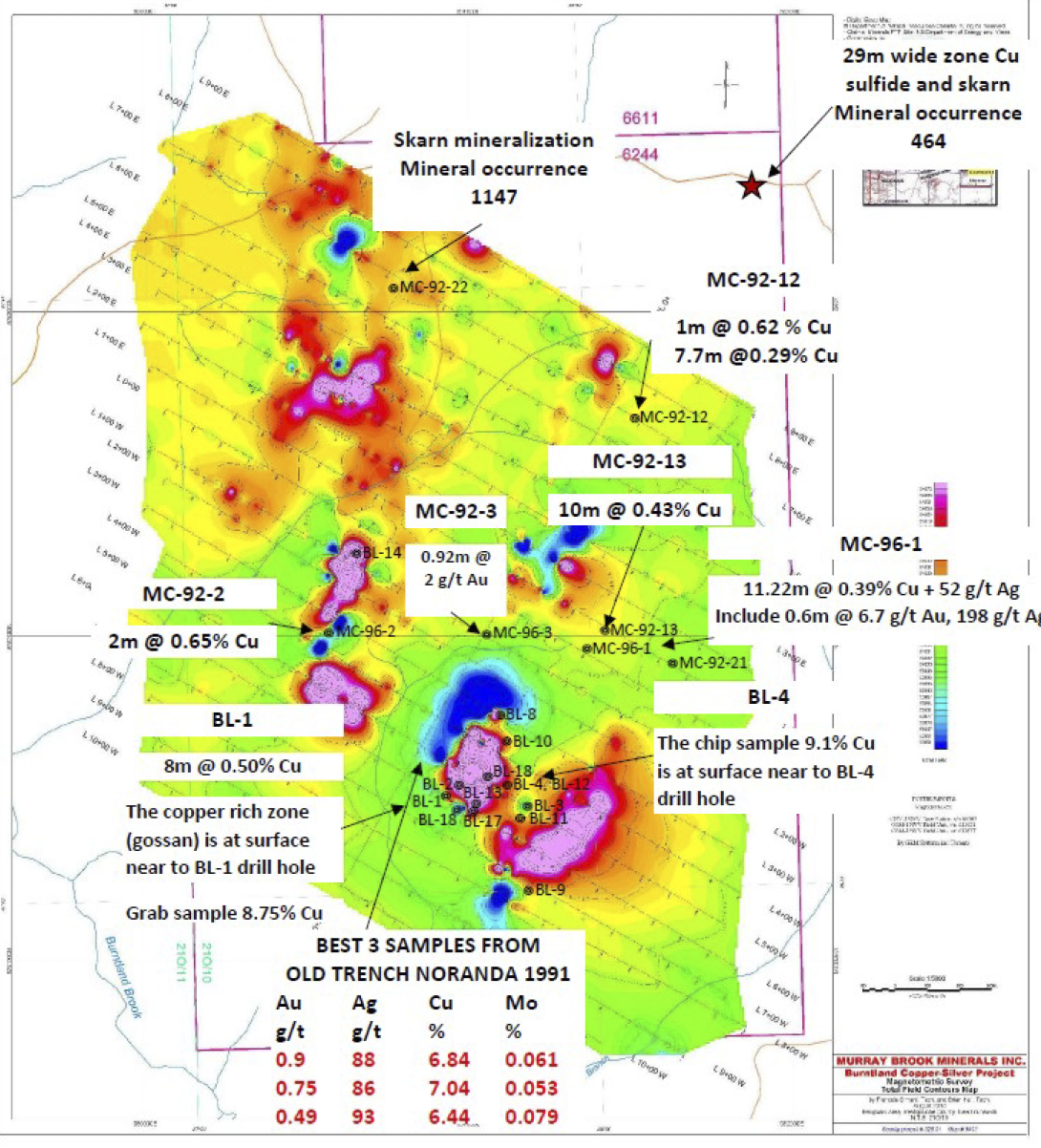
Figure 1: Exploration History of Burntland deposit, Noranda trenching, its results are described fully by Albert Keevil drilling (BL series 1969), and Murray Copper drilling (MC holes)
The skarn mineralization is not contained in the feldspar-porphyry or the hornfels-porphyry rock. All the mineralization in the area is contained with the whitehead suite (Matapedia Group), the Silicified-limestone/siltstone which is situated around these Porphyries. The Skarns are scattered around the property but all lie within the 150-180 strike range dipping at 80 degrees on the surface. These dykes have no Cu content on the surface but it appears that there is a higher amount of Cu percentage as depth increases. Mines in Gaspe (Murdockville) showed halos of mineralization on the outskirts surrounding the deposit. But the deposits are too deep to be discovered with surface methods. (474330)
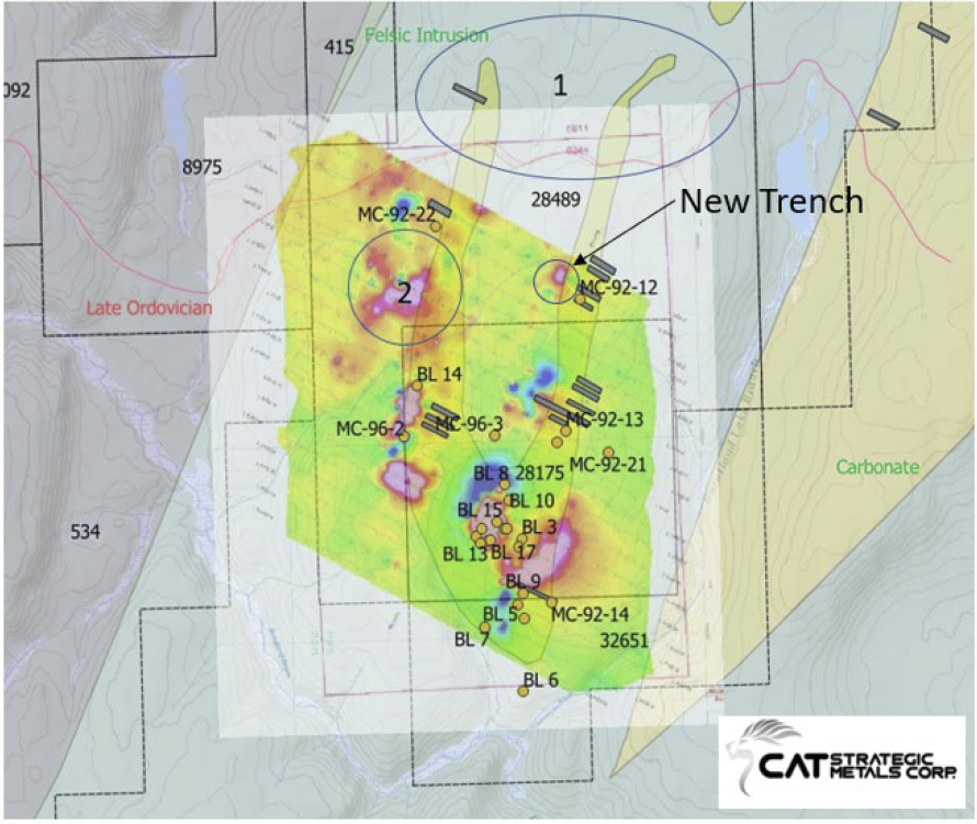
Figure 2:: Map of Burntland property with Hornfels-porphyry, 1,2 show the work proposed
There are skarn occurrences throughout the drill record from 1969, and many overlying segments of skarn/limestone and porphyry.
The porphyries are of the feldspar-quartz type and the hornflelds-plagioclase type. The skarns vary from reddish-brown in color denoting a higher Fe content to green garnetiferous skarn. The skarn also hosts epidote and chalcopyrite in varying amounts. The copper mineralization is intermittent showing 2.44% in a 2m section and dropping down to 0.3% in another. These layers are being compressed by the fold and forming thin sections in the drill log; compression leads to fractures, and fractures to fluids. In a 2020 paper, R. Lentz said that these skarns were formed from a body between 8-12 km below, supplying the necessary fluid to mineralize these skarn rocks. Skarns form from Porphyries and are contained ~1-2 km away from the source. With these skarns at the surface there is an exceptionally good possibility of a proximal skarn within drilling distance.
“The high oxidation states and water content of magmas control the behavior of sulfur and metal partitioning into the fluid phases and are critical for the generation of magmatic-hydrothermal Cu – Au deposits (Candela and Holland, 1984; Richards, 2005, 2009; Ayati et al., 2013). Consequently, oxidation state and water content of these slab failure magmas play an important role in assessing their potential to form ore deposits.” (R. Lentz, 2020)
The quaternary report by Rampton V.N (1984) shows that the till is mainly:
“Blanket and veneer: loamy lodgment till, minor ablation till, silt, sand, gravel, rubble Mb – blanket, generally 0.5 to 3m thick Mv – discontinuous veneer over rock, less than 0.5m thick sMb, sMv – mainly sandy till (sand content greater than 50%) aMb, aMv – mainly stony till (more than 35% of clasts pebble-sized and larger) bMb, bMv – mainly boulder till (more than 25% of clasts boulder-sized)”
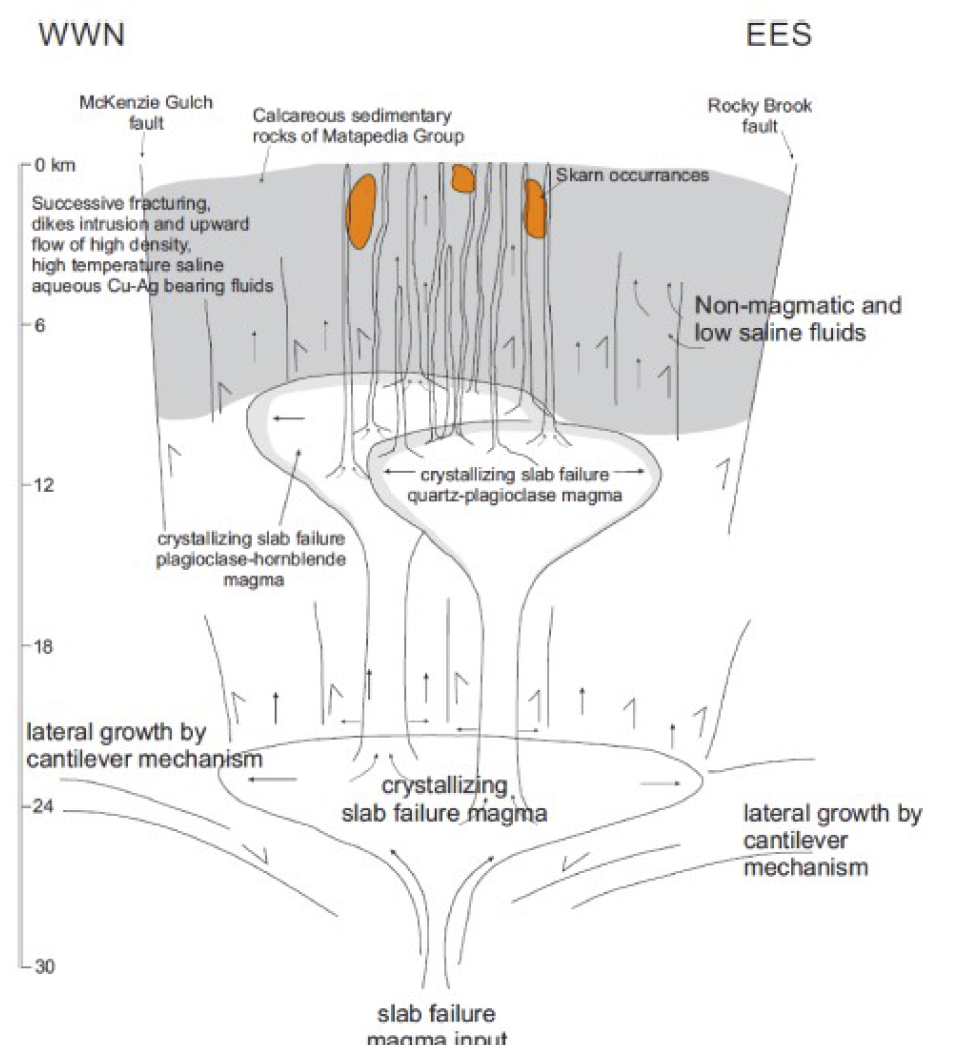
Figure 3: Pluton underneath the Burntland area, showing skarns in orange
The assays returned more conservative values than the previous sampling. The independent analysis reveals, however, that there is good mineralization in the rocks. No ‘picking’ to offset the samples.
B567651 (2.6 % Cu, 59.6 g/t Ag)
B567660 (5.3% Cu, 54.1 g/t Ag)
B567655 (0.97% Cu, 3.12 g/t Ag)
B567657 (0.65% Cu, 2.31 g/t Ag)
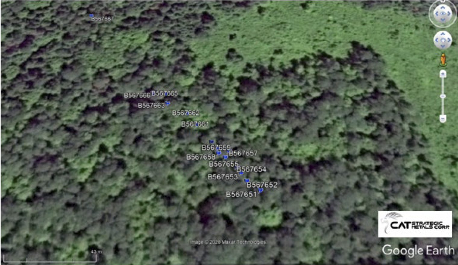
Figure 3: Pluton underneath the Burntland area, showing skarns in orange
One can state however, that the mineralization occurs throughout the carbonate-Argillite facies (Sed-skarn) and not the porphyry dykes. The focus of the sampling was to determine the copper content of the porphyry rocks which have little to no copper amounts. These samples (B567666 and B567667) were taken to determine the idea of a porphyry type deposit. There is no evidence to definitively indicate this now. However, the porphyry rocks that are associated with the felsic dykes have an elevated Cu content of 0.02% which is promising, and the garnet-skarn has a higher percent 0.65-0.97% Cu. It should also be noted that these samples are not a definitive sample series. They were taken by eye, not in a series standard sampling process. Samples were taken at the Geologists discretion to provide samples that represented all the facies types. Judging by the area of mineralization found in the new trench there is enough Cu percentage to justify further exploration on the property. Argillaceous-Limestone is found throughout trenches dug in the area. These holes were drilled in 1995-1996 by Noranda and uncovered 6.84 % Cu 88 g/t Ag and 6.44% Cu 93 g/t Ag.